Army, CFS tell KI residents to evacuate as fires again take hold
UPDATED | Three emergency warnings are now in place for the bushfire-ravaged Kangaroo Island, with residents of Vivonne Bay and Parndana advised to leave their homes as authorities battle with severe conditions.

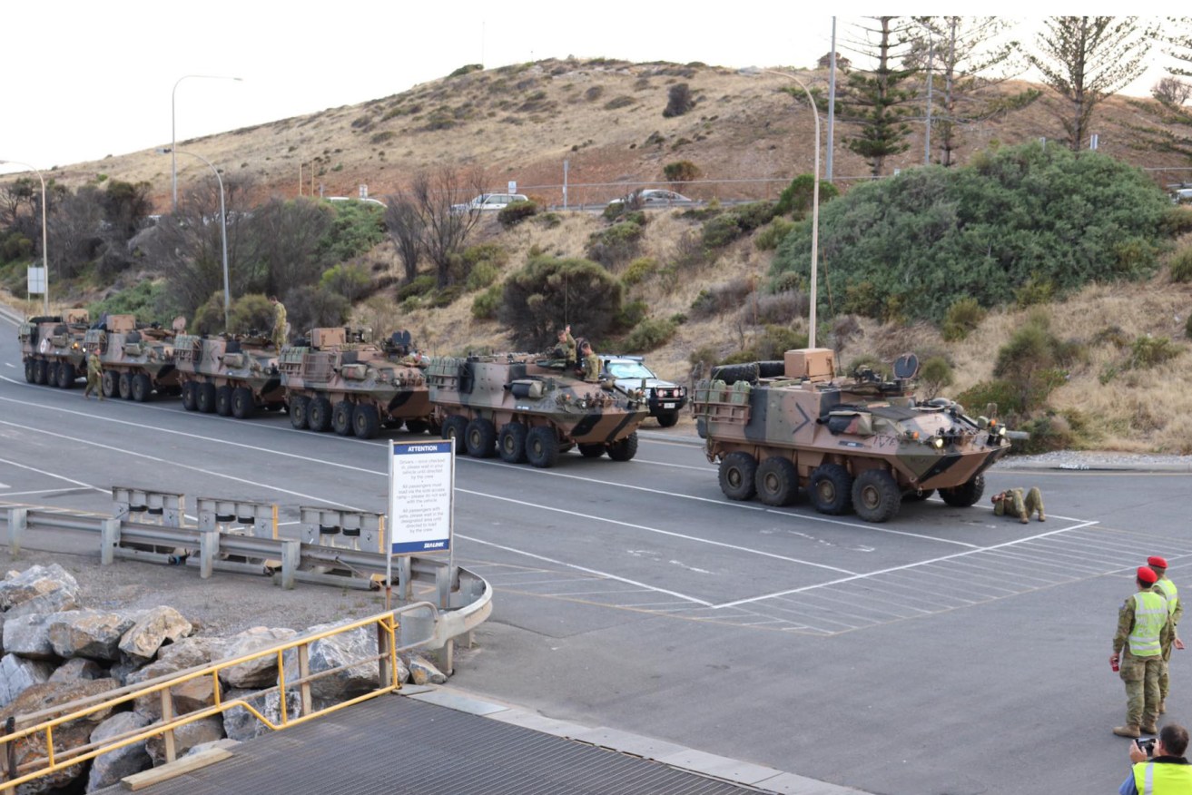
Six Australian Army armoured personnel carriers arrive in Kangaroo Island. Photo: Leon Bignell / Facebook
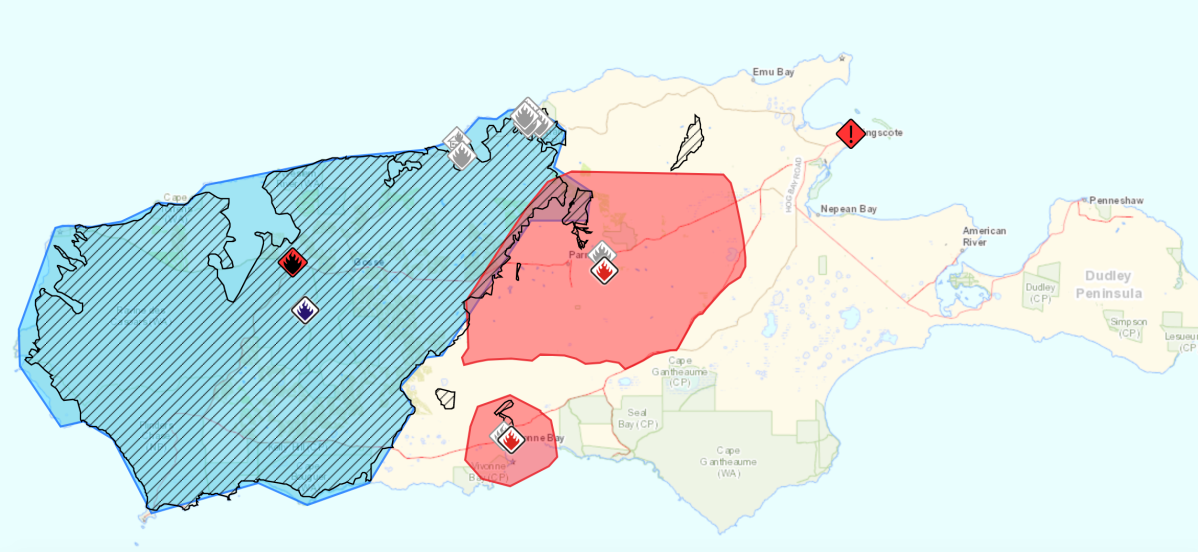
The Country Fire Service this afternoon issued emergency warnings for three uncontrolled bushfires at Vivonne Bay on the island’s south coast and two east and west of Parndana on the north coast.
Army personnel this morning door-knocked Parndana residents urging them to evacuate as two fires threatened the town.
One is heading away from the town in a southerly and easterly direction, but a second one is burning to the west near McHughs Road, in a south-easterly direction.
The CFS issued a separate emergency warning for the Ravine fire earlier this afternoon saying it was bearing south towards Vivonne Bay Township, Harriet Road, South Coast Road and Knofel Drive, with conditions continually changing.
Residents were evacuated from Vivonne Bay last night.
#Bushfire Emergency Warning for #PLAYFORD_HWY/WEST_END_HWY_,_RAVINE #fire. This fire may pose a threat to lives directly in its path. Act now. Leave if the path is clear to a safer place, as it will soon be too dangerous to drive. #EWM ID=0004586 #SAFires https://t.co/NUhX28rKPt pic.twitter.com/xr7FMFezY3
— Country Fire Service (@CFSAlerts) January 9, 2020
The entire western side of Kangaroo Island is warned to look out for potential uncontrolled bushfires.
Firefighters believe the towns of Parndana and Vivonne Bay may be spared total destruction, with CFS deputy incident controller Ray Jackson saying a wind change that came earlier than forecast had pushed the fire fronts to the east.
“It’s safe to say that currently Parndana is still of a concern but the fire is not expected to run into there with a high intensity,” he said.
He said a similar situation was also expected for Vivonne Bay with the CFS “hopeful” the shacks and properties along the southern coast of the island would be okay.
Jackson said the fire was currently running along the Cygnet River towards Kingscote but the island’s largest town was not considered at risk and residents were not being asked to leave.
“We’re quite comfortable that if anything does come up we can do that because it is a safer place,” he said.
The CFS was also hopeful that cooler conditions and some rain heading into Friday would allow crews to better contain the running fires and strengthen containment lines.
https://twitter.com/FrankPangallo/status/1215100655095803904
CFS crews also dealt with major flare-ups on the north coast today, with water bombing conducted at Stokes Bay.
Fire outbreaks at Deep Creek Gully, Bark Hut and Yarda remain uncontrolled.
BREAKING: Army officers going door to door evacuating residents in Parndana. They’ve been given 5 minutes to pack up their belongings & leave.
@10NewsFirstAdl pic.twitter.com/TnXUjJr2S4— Hannah Foord (@HannahFoord10) January 9, 2020
Vivonne Bay was evacuated last night amid fears homes could not be protected.
Made up of mostly holiday shacks, it’s thought less than 100 people live in the south coast town at any given time.
Police went door to door, calling on residents to head for safety at Kingscote or Penneshaw, but some still chose to stay.
Those who left will not be allowed to return until Friday, but only if it is then deemed safe.
“This is a pre-emptive relocation due to the increased fire risk,” the CFS said.
“Currently, there is no immediate threat to life or property but with increasing wind, warmer weather and ongoing fires on Kangaroo Island, this situation is likely to change.”
Vivonne Bay was only just spared last week when fire roared through over 160,000 hectares across the western third of the island, destroying 56 homes.
At the peak of the emergency last week, Parndana also came under threat with locals saying the glow in the sky was “just incredible.”
The Defence Force has deployed six armoured personnel carriers based at Edinburgh in Adelaide’s north to Kangaroo Island to assist with the recovery effort.
Kangaroo Island faced another day of severe fire today with high temperatures and winds.
CFS assistant chief officer Rob Sandford told ABC Radio Adelaide this morning Kingscote and Penneshaw remained the safest places on the island.
“The communities have been at it, doing it tough, but hopefully today we can prey for the best and hope that no communities are threatened, but unfortunately also the conditions are going to make it tough,” he said.
“Vivonne Bay is an area unfortunately if the fire escapes may be threatened.”
All roads on the western side of the island are currently closed, with the CFS warning those that are open – including Playford Highway and Timber Creek Road – may become unsafe to travel as the fire progresses today.

The western side of Kangaroo Island is under an advice warning while three emergency warnings are in place near Parndana and Vivonne Bay. Image: CFS
Meanwhile, a grass fire that burnt about four hectares in Kersbrook near the Barossa Valley has been contained and police are now investigating it.
The CFS said the threat from that fire has been reduced, but smoke would reduce visibility on the roads and there was a risk of trees and branches falling.
Total fire bans and a fire danger rating of severe have been declared for six districts including Lower Eyre Peninsula, Mid North, Mount Lofty Ranges, Yorke Peninsula, Kangaroo Island and the Lower South East.
A #FireWeatherWarning has been issued for South Australia for tomorrow. Severe fire dangers are forecast for 6 districts, including the Mount Lofty Ranges and Kangaroo Island. Hot to very hot with fresh NE to NW’ly winds ahead of a gusty SW’ly change. https://t.co/S9J4YumHyE pic.twitter.com/QWfon4gHN0
— Bureau of Meteorology, South Australia (@BOM_SA) January 8, 2020
Tanner said the CFS had used back burning in the past few days to strengthen control lines on the island.
“Although we often use back burning as a method to fight fires, there is meticulous planning that goes into these burns before they are lit,” he said.
“We also deploy many resources to ensure the fire is well controlled.”
There will be no back burning in place today due to forecasted increased winds.
SA Power Networks has restored power to nearly half of its customers in Vivonne Bay, but it said restoration efforts are on hold today due to escalating weather conditions.
Our crews are working to reconnect power to customers. We have a taskforce assessing damage & organising full restoration of power to customers whose property and/or business has been impacted. This will be a lengthy process due to the extent of the damage. pic.twitter.com/rRHUI0irV3
— SA Power Networks (@SAPowerNetworks) January 8, 2020
Mobile phone services on Kangaroo Island have been restored, while work is continuing to restore landlines affected by the bushfires.
Two people – 78-year-old pilot Dick Land and his 43-year-old son Clayton – were killed as they tried to return to the family property on Friday.
Authorities have estimated more than 100,000 sheep, about 4000 cattle and 1000 beehives have been destroyed on Kangaroo Island since fires started on January 3.
Ecologists have also estimated 25,000 koalas have perished in the fire, which is half the island’s population of the animals.
Alongside the 56 homes destroyed, 10 buildings suffered major damage and 257 vehicles were decimated.
The State Government today announced it would provide grants of up to $10,000 to sporting clubs affected by the Kangaroo Island and Cudlee Creek bushfires.
Uniting Communities announced today it would make its Franklin Street “U City” serviced apartments temporarily available at no charge to people who have lost their homes in the bushfires.
A satellite image captured by NASA’s Terra satellite shows burn scars on one third of Kangaroo Island.
Bushfires have been ravaging Australia’s Kangaroo Island, which is home to native wildlife such as sea lions, koalas and endangered bird species. Our @NASAEarth satellites are monitoring the extent of the damage and the areas continuing to burn. https://t.co/WqdjzEgF6c pic.twitter.com/StI7CQEPum
— NASA (@NASA) January 7, 2020


